"A Walk on the Moors" - John's Pennine Way Ramble, Day 15 - July 15th 2000, Bellingham to Byrness |
|---|
| Day | Date | Start | Finish | Approx. Miles | Hours Taken | Accommodation |
| 15 | Sat. 15th July | Bellingham | Byrness | 16 | 6 | YHA - 7 Otterburn Green, Byrness, NE19 1TS, Tel. 01830 520425 |
Click on any picture to go to a larger
version. ![]() to go to the full set of Pennine Way photographs for this
day.
to go to the full set of Pennine Way photographs for this
day.
 Day fifteen, the penultimate Walk on the Moors and a mere
16 miles. Two weeks ago I'd have thought 16 miles to be a long way to walk. Now
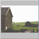
it was just a stroll! Leaving our overnight stay, Crofter's End, I forgot to
take the usual starting photo so Noelene took this one out of the window of the
car much later on. She drove me into town (I'd walked there the previous day)
and I met my Yorkshire partners, leaving at about 09:05. The weather was clear
but overcast with a light cool breeze as we headed out of the splendid little
town (large village?) of Bellinjum. I felt on top of the world today.
There was just one more long day to do after this walk and I was determined to
get as much enjoyment from the remaining miles as possible.
Day fifteen, the penultimate Walk on the Moors and a mere
16 miles. Two weeks ago I'd have thought 16 miles to be a long way to walk. Now
it was just a stroll! Leaving our overnight stay, Crofter's End, I forgot to
take the usual starting photo so Noelene took this one out of the window of the
car much later on. She drove me into town (I'd walked there the previous day)
and I met my Yorkshire partners, leaving at about 09:05. The weather was clear
but overcast with a light cool breeze as we headed out of the splendid little
town (large village?) of Bellinjum. I felt on top of the world today.
There was just one more long day to do after this walk and I was determined to
get as much enjoyment from the remaining miles as possible.
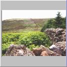
We walked uphill along a tarmac road as we headed north out of town and into fields towards a farm. The Way was soft under foot and, on terrain like this, I could have walked all day instead of just the six hours we reckoned it would take us to get to Byrness, today's destination. We went through Blakelaw Farm's yard where the sheep were being given their annual haircut and continued over more fields where the track was soft and well marked. We had a fine view of the town and it's a place I'd like to return to sometime and explore in more detail. Apparently we passed near by Hareshaw Linn, an especially pretty waterfall. But we didn't stop to look for it as we were keen to make good progress.
 The Way continued to climb slowly, crossing a road (B6320 again)
where the route was signposted as Alternative Pennine Way. Now, I know
that there is actually an (unofficial) long distance trail called by that name
but I'm pretty sure that this wasn't it. We crossed Lough Shaw, walking through
heather for a while and to a part of the Way on which Uncle Harry reckoned he
always gets lost. But, thanks to my expert navigating skills, there were no
problems this time. The path was very clear and well signed to the top of
Whitley Pike, where we crossed a farm track and began to climb alongside Padon
Hill (379 m).
The Way continued to climb slowly, crossing a road (B6320 again)
where the route was signposted as Alternative Pennine Way. Now, I know
that there is actually an (unofficial) long distance trail called by that name
but I'm pretty sure that this wasn't it. We crossed Lough Shaw, walking through
heather for a while and to a part of the Way on which Uncle Harry reckoned he
always gets lost. But, thanks to my expert navigating skills, there were no
problems this time. The path was very clear and well signed to the top of
Whitley Pike, where we crossed a farm track and began to climb alongside Padon
Hill (379 m).
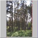
After Padon Hill the well restored path turned into a real muddy morass as we climbed between the edge of a part of the Kielder Forest and a stone wall up to Brownrigg Head. Elaine described this part of the walk as "disgusting, disgusting, disgusting". And it was! She reckoned that the start of tomorrow's final leg begins like this. So I wasn't well chuffed to say the least. Once we were clear of the trees we trudged over, or rather through, very wet, boggy ground where the boundaries were marked with stones carrying the initials GH for Gabriel Hall, High Sheriff of Nottingham in 1705.
What a contrast between this awful boggy morass and the well restored path in the lea of Padon Hill. Once the Way entered Kielder Forest proper the going was no better. I did an unobserved A over T, almost wrenching my knee but with no real damage. Ever since Malcolm (Greenhalgh - an old guy who I used to run with) told me of someone he'd accompanied along the Way in the 70s twisting an ankle on the last leg and being carted off to hospital, I've had a fear of doing something similar myself and I did twist my ankle quite badly on one of the practice walks.
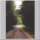 After a while the Way joined one of the forest service roads and
there were then seemingly endless miles of track through the same monoculture
of coniferous trees that we'd first experienced the day before. Much of it
appeared to have been damaged by the wind. The path was hard and stony and,
although there was some relief from the Sorbothane inners, my feet were really
painful again.
After a while the Way joined one of the forest service roads and
there were then seemingly endless miles of track through the same monoculture
of coniferous trees that we'd first experienced the day before. Much of it
appeared to have been damaged by the wind. The path was hard and stony and,
although there was some relief from the Sorbothane inners, my feet were really
painful again.
 Eventually we reached Blackenhopeburnhaulgh Farm
(the longest English place name) where there is a picnic area and toilets and
we stopped for a while for a drink and something to eat. But the midges began
to attack in what we thought might be a foretaste of tomorrow's start so we
moved quickly on. We passed a guy in a camper van watching TV. What a strange
thing to do in such a nice area. The Way crossed the River Rede, a quite
pleasant little water course that I'd never heard of before. We joined a forest
trail, this one much better for walking on and it carried us alongside the
river for quite a while.
Eventually we reached Blackenhopeburnhaulgh Farm
(the longest English place name) where there is a picnic area and toilets and
we stopped for a while for a drink and something to eat. But the midges began
to attack in what we thought might be a foretaste of tomorrow's start so we
moved quickly on. We passed a guy in a camper van watching TV. What a strange
thing to do in such a nice area. The Way crossed the River Rede, a quite
pleasant little water course that I'd never heard of before. We joined a forest
trail, this one much better for walking on and it carried us alongside the
river for quite a while.
After crossing by a footbridge we walked on a little and there was Noelene sitting in the car sketching the Holy Trinity Church, a fine looking small stone building. From there we took another path towards Byrness village and we met Don Christon, the retired Warden of Byrness YH. We reached the hostel itself, a couple of converted Forestry Commission houses, shortly afterwards.
Byrness YH is self catering so Noelene had bought provisions to cook an early breakfast for us the next day (what a love she is!). We were then able to relax, bar the neighbours' lawn mowers, in the sun on the lawn at the back of the YH. We didn't see Peter that day but Noelene had taken his tent and some other gear to the Byrness Hotel where he camped for the night and where we joined him for some grub and a beer or two later on.
We tried to get an early night but it took me ages to go to sleep for thinking of the big one, tomorrow. What a day that would be.
Day fifteen should have been special since it was the penultimate walk of the great trek. But it didn't feel like that. There were some very pleasant parts such as the walk up from Bellingham and Padon Hill. But the never ending forest tracks and the disgusting path before Brownrigg Head stay in the memory more. The last couple of miles were quite pretty, especially the walk along the banks of the River Rede. There's not much to Byrness itself, just a petrol station, a hotel, church and, further along the road, a cluster of Forestry Commission houses, two of which form the YH.
No, day fifteen wasn't anything really special. But tomorrow would be a another story altogether.
Grub: |
Booze: |
![]() to go to Day
16,
to go to Day
16, ![]() to go back
to the itinerary or
to go back
to the itinerary or ![]() to return to the
starting page.
to return to the
starting page.