"A Walk on the Moors" - John's Pennine Way Ramble, Day 14 - July 14th 2000, Greenhead to Bellingham |
|---|
| Day | Date | Start | Finish | Approx. Miles | Hours Taken | Accommodation |
| 14 | Fri. 14th July | Keld | Baldersdale | 25 | 9.75 | B&B - Mr. & Mrs. Foster, Crofters End, The Croft, Bellingham, Hexham, Northumberland, NE48 2JY, Tel. 01434 220034 |
Click on any picture to go to a larger
version. ![]() to go to the full set of Pennine Way photographs for this
day.
to go to the full set of Pennine Way photographs for this
day.
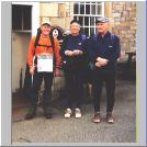 Anything had to be better than the awful walk from Alston to
Greenhead the previous day and I set off with Harry and Elaine on the twenty
five miles of the fourteenth day knowing that there was a long trek ahead over
difficult countryside. We left early, at 08:15, with clear but cool and
overcast weather. Peter had camped nearby and we knew that he'd either meet up
with us or we with him at some point during the day. The evening before, Harry
and I had gone out in the car to find out exactly which way the route was to
take us in the morning. Because we didn't want to go wrong (famous last words)!
Anything had to be better than the awful walk from Alston to
Greenhead the previous day and I set off with Harry and Elaine on the twenty
five miles of the fourteenth day knowing that there was a long trek ahead over
difficult countryside. We left early, at 08:15, with clear but cool and
overcast weather. Peter had camped nearby and we knew that he'd either meet up
with us or we with him at some point during the day. The evening before, Harry
and I had gone out in the car to find out exactly which way the route was to
take us in the morning. Because we didn't want to go wrong (famous last words)!
I'd originally planned to do this leg of the Way in two days with an overnight stop at the wonderfully named Once Brewed Youth Hostel. But Harry had called me a wimp and, stupidly for me, I rose to his bait. So I was to break another personal distance record during the day. We headed north out of Greenhead, up the road, across the railway line and Pow Charney Burn, carefully following Tony Hopkins guide, past the being renovated Thirwall Castle. After a while we could see another village to our right and we couldn't figure out which one it was. Because, as far as we knew, Greenhead was the only one in the area! It was only when we reached a road, after about half an hour's walking, and looked down it that we realised we had reached Greenhead II. Yes, indeed, there are two of them, completely identical, both with Greenhead Hotels and Youth Hostels and the second one is such a secret that it's in none of the guide books or on any of the maps. In fact, I'm not really supposed to mention on the Internet at all!
We decided to take an alternative route as we were afraid of getting stuck in this identical dimension. Groundhog Day sprung to mind. So we continued up a road, and to the Roman Army Museum entrance where we turned right, returned to our own time and space continuum and carried on towards Hadrian's Wall.
 All I
can say is that that there Adrian must have been quite a builder, but we reckon
he had a big gang of Italians to help him. The wall itself is only a shadow of
the one he built, which was about 120 km long and 15 m high. Hadrian was
supposed to have been a fit man and enjoyed walking. But I bet he never did the
Pennine Way. Even in its diminished state the wall is very evocative and it's
not too difficult to sympathise with the poor Centurions stationed in this far
flung post of the Roman Empire, fighting off the Scottish barbarians (nothing's
changed there then!), rather than being sent to the south of France to
supervise the Empire's vineyards!
All I
can say is that that there Adrian must have been quite a builder, but we reckon
he had a big gang of Italians to help him. The wall itself is only a shadow of
the one he built, which was about 120 km long and 15 m high. Hadrian was
supposed to have been a fit man and enjoyed walking. But I bet he never did the
Pennine Way. Even in its diminished state the wall is very evocative and it's
not too difficult to sympathise with the poor Centurions stationed in this far
flung post of the Roman Empire, fighting off the Scottish barbarians (nothing's
changed there then!), rather than being sent to the south of France to
supervise the Empire's vineyards!
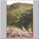 We met Peter just before the wall and recounted to him our
contact with another time and dimension at Greenhead. He was amazed! The four
of us walked together along the wall for a while but Uncle, Auntie and I soon
got fed up with the constant ups and downs so we took the alternative lower
route along the Roman Military Road, a supply route for the wall garrisons.
This was a difficult trail and we would probably have been as well to have
stuck close to the wall. We ended up on a road (the B6318) and walked quite a
way along it to the Once Brewed Youth Hostel and the Twice Brewed Inn before
heading north up the road to Steel Rigg car park where I stoped to meet Noelene
as the others continued on. The sweetheart had been all the way back into
Alston to get me a pair of Sorbothane inners for my boots in an attempt to
relieve my poor sore feet. So I installed them there and then but had to remove
my thicker outer socks to stop my boots being too tight. But it was a bit
better and I was so grateful to her.
We met Peter just before the wall and recounted to him our
contact with another time and dimension at Greenhead. He was amazed! The four
of us walked together along the wall for a while but Uncle, Auntie and I soon
got fed up with the constant ups and downs so we took the alternative lower
route along the Roman Military Road, a supply route for the wall garrisons.
This was a difficult trail and we would probably have been as well to have
stuck close to the wall. We ended up on a road (the B6318) and walked quite a
way along it to the Once Brewed Youth Hostel and the Twice Brewed Inn before
heading north up the road to Steel Rigg car park where I stoped to meet Noelene
as the others continued on. The sweetheart had been all the way back into
Alston to get me a pair of Sorbothane inners for my boots in an attempt to
relieve my poor sore feet. So I installed them there and then but had to remove
my thicker outer socks to stop my boots being too tight. But it was a bit
better and I was so grateful to her.
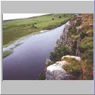 I caught up with the other three and we continued along this
fairly well preserved section of the wall for a while and had a great view of
the rather super Crag Lough, complete with swans a swimming (although you can't
see them in this picture, despite the caption!).
I caught up with the other three and we continued along this
fairly well preserved section of the wall for a while and had a great view of
the rather super Crag Lough, complete with swans a swimming (although you can't
see them in this picture, despite the caption!).
 At Rapishaw Gap we left the wall and turned north again, across
Ridley Common with the going much easier than earlier. We soon entered the
twilight zone (for the second time in one day!) of the Forestry Commission's
Wark Forest. This, despite its monoculture of Norwegian Spruce (or some sort of
fir tree) was interesting nonetheless in the same sort of way that the bleak,
monotonous moors have their own special charm. We'd feared that, after our
experience at Alston, the midges would be out in force in the forest and
Noelene had bought me a mosi-net to cover my head (a bit like a fine
version of an Ena Sharples hair net - remember her?). But they were nowhere to
be seen (must have been my aftershave) and the nets were, thankfully, not
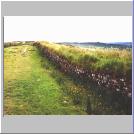
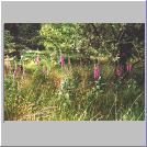
needed. After the first forest the track took us over rather boggy moorland
(Hawk Side) and into more woods. This time the trees were a mixture of
deciduous and conifers rather than the previous monoculture and there was a
profusion of foxgloves in flower. And very pretty they looked too.
At Rapishaw Gap we left the wall and turned north again, across
Ridley Common with the going much easier than earlier. We soon entered the
twilight zone (for the second time in one day!) of the Forestry Commission's
Wark Forest. This, despite its monoculture of Norwegian Spruce (or some sort of
fir tree) was interesting nonetheless in the same sort of way that the bleak,
monotonous moors have their own special charm. We'd feared that, after our
experience at Alston, the midges would be out in force in the forest and
Noelene had bought me a mosi-net to cover my head (a bit like a fine
version of an Ena Sharples hair net - remember her?). But they were nowhere to
be seen (must have been my aftershave) and the nets were, thankfully, not
needed. After the first forest the track took us over rather boggy moorland
(Hawk Side) and into more woods. This time the trees were a mixture of
deciduous and conifers rather than the previous monoculture and there was a
profusion of foxgloves in flower. And very pretty they looked too.
 We crossed the B6320 to Stonehaugh,
where I'd considered camping until I found that there was only a cold water tap
on the site ("what me, a wimp"!). Anyhow, we sat on a wall and ate a
butty (sausage, of course - culled from the morning's breakfast) before passing
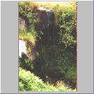
through more woodland and over Ground Rigg (a small hill) to a smashing little
waterfall from Fawlee Sike (a sike is a stream in these parts). Not long after
that we saw a newly born foal suckling from its mother, our third dead sheep of
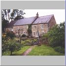
the walk, squelched our way through another muddy morass and reached Lowstead.
This is where the Pennine Way goes through the garden, almost across the lawn
and beneath the front windows. It's a beautiful house and now does B&B but
at a price that only the wealthiest of walkers would be able to afford (or so
Uncle Harry reckoned).
We crossed the B6320 to Stonehaugh,
where I'd considered camping until I found that there was only a cold water tap
on the site ("what me, a wimp"!). Anyhow, we sat on a wall and ate a
butty (sausage, of course - culled from the morning's breakfast) before passing
through more woodland and over Ground Rigg (a small hill) to a smashing little
waterfall from Fawlee Sike (a sike is a stream in these parts). Not long after
that we saw a newly born foal suckling from its mother, our third dead sheep of
the walk, squelched our way through another muddy morass and reached Lowstead.
This is where the Pennine Way goes through the garden, almost across the lawn
and beneath the front windows. It's a beautiful house and now does B&B but
at a price that only the wealthiest of walkers would be able to afford (or so
Uncle Harry reckoned).
After Lowstead there was a seemingly very long walk along tarmaced roads and
a steep climb up to Shitlington Crags (I love that name!). We stopped for a
while to admire the fine view but my feet and legs were, by now, so painful
that I didn't appreciate it as much as I should have. From the Crags I lead the
way (without getting lost!) over rushy moorland and up to the TV mast, along
another tarmac road, a footpath and more rushy moorland to Fell End and a view
of Bellingham, our day's destination. As we walked down towards the town a
blustery rain began to fall and, after about 24 miles, we had to put on
waterproof jackets. 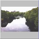 The Way follows the B6320 again, along
the River North Tyne, but there's no view of the river and the road is
dangerously busy with quarry wagons. As we passed a house on the outskirts of
town a lady called to us "Are one of you mine?" and that was Mrs.
Foster, Noelene and I's landlady for the night. So I dumped my gear and walked
into town with the others to meet Noelene.
The Way follows the B6320 again, along
the River North Tyne, but there's no view of the river and the road is
dangerously busy with quarry wagons. As we passed a house on the outskirts of
town a lady called to us "Are one of you mine?" and that was Mrs.
Foster, Noelene and I's landlady for the night. So I dumped my gear and walked
into town with the others to meet Noelene.
Bellingham (pronounced Bellinjum for some reason best know to the locals) is a smashing little town. It's very unusual for being the only place I know with a memorial to the Boer War and a cannon from the Chinese Boxer Rebellion. We did a bit of shopping for the following day's packed lunch and, after a good soak in the bath, met the others for a meal at one of the pubs
We at last met the famous "Dutch Couple" and gave them a heroes' welcome at which they were very surprised. Peter and Mereka (or Meryka) are a lovely couple, walking from Land's End to John O' Groats in the three months that they managed to take off work. He's a professional gardener and she a bookkeeper and, boy, were they slim! We toasted their health with a couple of pints of John Smiths Smoothflow Bitter (yuk!) and had the most enormous meal I've ever seen in a pub. I was the only one to eat the lot.
We repaired to our boudoir well satisfied.
What a contrast day fourteen was with the previous day. Although (or because) it was my longest walk ever I felt great and all the enthusiasm I'd lost on the dreadful trek from Alston to Greenhead was back again. There were just two more days to the finish and I was determined to enjoy every painful step of the way. Even though we weren't in Scotland yet it felt a bit like we were, probably because of the physical barrier between the north and south that Hadrian's Wall represents. We had our first encounters with forests and it wasn't as bad as I'd feared and we'd seen a lot of very interesting and, at times beautiful, sights.
Bellingham is a place well worth a separate visit. It's not the most beautiful of towns, but it ain't bad, the people are very friendly and it's unusual in some respects. We also met the Dutch End to Enders and that was a bonus too.
I liked day fourteen.
Grub: Chips (couldn't manage anything else!) |
Booze:
|
![]() to go to Day
15,
to go to Day
15, ![]() to go back
to the itinerary or
to go back
to the itinerary or ![]() to return to the
starting page.
to return to the
starting page.